Today a 30 percent chance of showers and thunderstorms, mainly after 3pm. Partly sunny, with a high near 92. Northeast wind 5 to 10 mph becoming east in the afternoon. Tonight a 10 percent chance of showers and thunderstorms before 7pm. Partly cloudy, with a low around 73. Southeast wind 5 to 10 mph becoming southwest after midnight.
Txtoast 3OP
~ 1 year, 11 mos ago
Jun 4, '22 2:50pm
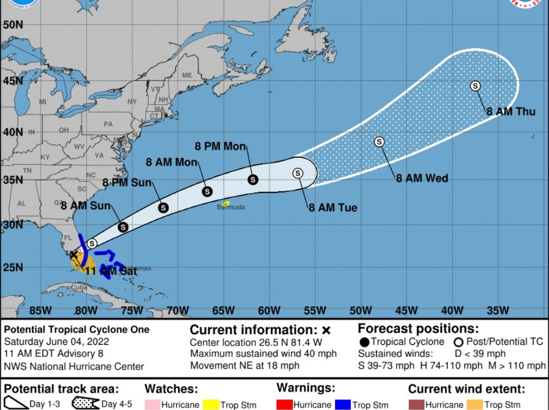
NOAA NWS National Hurricane Center reports at 11am on Saturday, 6/4.
..DISTURBANCE NOW CROSSING SOUTH FLORIDA… ...FLOODING RAINS OCCURRING ACROSS PORTIONS OF SOUTH FLORIDA... At 1100 AM EDT (1500 UTC), the disturbance IS ABOUT 35 MILES (60 km) northeast of Naples, Florida. The system is moving toward the northeast near 18 mph (30 km/h), and this general motion is expected to continue through tonight. A turn toward the east-northeast with an additional increase in forward speed is expected on Sunday, followed by a turn toward the east Monday night. On the forecast track, the disturbance is expected to move across southern or central Florida today, over the southwestern Atlantic north of the Bahamas tonight, and near or to the north of Bermuda on Monday.
Maximum sustained winds are near 40 mph (65 km/h) with higher gusts. The disturbance is expected to become a tropical storm off the east coast of Florida by tonight, and some strengthening is forecast tonight through Monday as the system moves farther away from Florida over the western Atlantic. It has a high (90 percent) chance of formation during the next 48 hours and during the next five days.
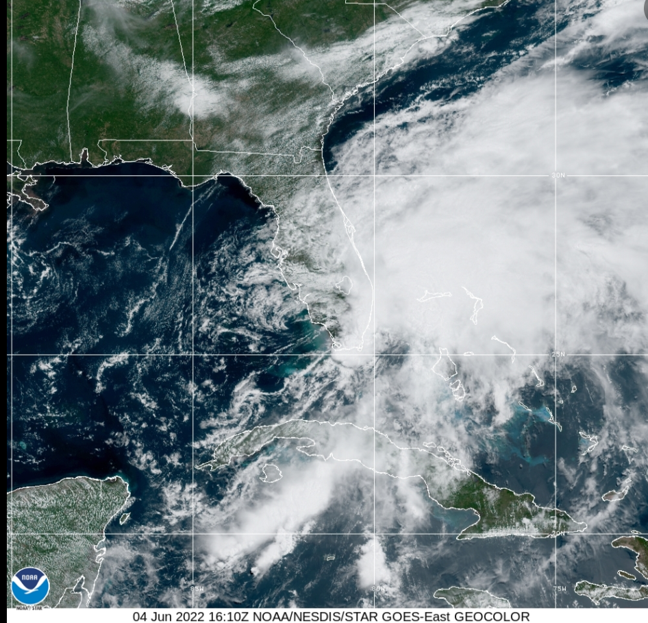
Satellite image a 4pm update: ...CENTER OF THE DISTURBANCE EMERGES INTO THE ATLANTIC EAST OF FLORIDA… ...FLOODING RAINS AND STRONG WINDS OVER PORTIONS OF THE NORTHWESTERN BAHAMAS… The Tropical Storm Warning has been discontinued for the east coast of Florida. At 500 PM EDT (2100 UTC), the disturbance is about 40 miles (65 km) northeast of Fort Pierce, Florida. The system is moving toward the northeast near 18 mph (30 km/h), and this general motion is expected to continue through tonight. A turn toward the east-northeast with an additional increase in forward speed is expected on Sunday, followed by a turn toward the east Monday night. On the forecast track, the disturbance is expected to move away from the east coast of Florida this evening, move over the southwestern Atlantic north of the Bahamas tonight, and move near or to the north of Bermuda on Monday.
NOAA Shares Flashy First Imagery from GOES-18 Lightning Mapper in 2 minutes time.
The Geostationary Lightning Mapper (GLM) instrument, onboard NOAA's GOES-18 satellite, is now providing striking lightning observations of the Western Hemisphere. GOES-18 launched on March 1, 2022.
GLM detects and maps total lightning-in-cloud, cloud-to-cloud, and cloud-to-ground-continuously over the Americas and adjacent ocean regions. GLM offers insights beyond the presence of a lightning strike, revealing the extent of lightning flashes and the distance they travel.
Rapid increases in total lightning activity often precede severe and tornadic thunderstorms. Characterizing lightning activity in storms allows forecasters to identify intensifying storms before they produce damaging winds, hail or tornadoes. GLM data enable forecasters to detect electrically active storms, determine the extent of the lightning threat, identify strengthening and weakening storms, monitor storm evolution, and supplement radar data where coverage is poor.
All this talk about showers... the only possible spot for showers seems to be in the bathroom.... I would rather have a shower than a bath !!!!!!!!!!!!!


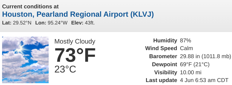


 a 30 percent chance of showers and thunderstorms, mainly after 3pm. Partly sunny, with a high near 92. Northeast wind 5 to 10 mph becoming east in the afternoon.
 a 10 percent chance of showers and thunderstorms before 7pm. Partly cloudy, with a low around 73. Southeast wind 5 to 10 mph becoming southwest after midnight.


.jpg)